Welcome to our website

Lorem ipsum dolor sit amet, consectetur adipisicing elit, sed do eiusmod tempor incididunt ut labore et dolore magna aliqua. Ut enim ad minim veniam, quis nostrud exercitation ullamco laboris nisi ut aliquip ex ea commodo consequat.

Duis aute irure dolor in reprehenderit in voluptate velit esse cillum dolore eu fugiat nulla pariatur. Excepteur sint occaecat cupidatat non proident, sunt in culpa qui officia deserunt mollit anim id est laborum. ed ut perspiciatis unde omnis iste.

Wisata Indonesia

Indonesia, situated between Asia and Australia / Oceania, is the world's largest archipelagic nation which has 17,508 islands. Indonesia lies between 6 degrees north latitude to 11 degrees south latitude, and from 97 degrees to 141 degrees east longitude

Kamis, 24 Februari 2011

Wisata Jatim Park Malang

The most visited tourist attractions in Kota Wisata Batu in East Java today is Park (East Java Park). Understandably tourist attraction on the slopes of Mount Panderman this is the most modern and best in the City of Stone Tour. Forum for the game too much and the scenery beautiful. Besides the cool air makes the resorts located at an altitude of 850 above sea level it is very suitable for people who come from hot areas.

Tourism concept which occupies 11 hectares of land that combines the ...

Sejarah Kota Malang

Malang is a city in East Java province, Indonesia. The city is located in a pretty cool highland, located 90 km south of Surabaya, and Malang is surrounded by territory. Malang is the second largest city in East Java, and known by the nickname of the city students.

The name "Malang" is still researched its origins by historians. Historians still continue to explore the sources to get the right answer on the origin of the name "Malang". Until now it has acquired several hypotheses about the origin of the name of Malang.

Malangkucecwara written in the symbol of the city, according to one hypothesis, the name of a sacred building. The name of the sacred building itself was found in two inscriptions of King Balitung of Central Java which is the inscription Mantyasih year 907, and 908 inscriptions that were found in one place between the Surabaya-Malang. However, where lies the true holy building Malangkucecwara that historians still do not get a deal. One party thought it was the location of the sacred building in mountain areas Burying, a mountain range that stretches to the east of the city of Malang, where there is a mountain peak named Malang. Proving the correctness of this conjecture is still underway, because it turns out, on the western town of Malang, there is also a mountain called Malang.
Other parties suspect that the real location of the shrine was located in the area Tumpang, one place in the northern city of Malang. Until recently in the area there is still a village named Malangsuka, which some historians, probably derived from the spoken word Malankuca reversed. The opinion above is also strengthened by the many ancient buildings are scattered in the area, such as Candi Jago and Candi Kidal, which both are relics of the kingdom Singasari.
Of the two hypotheses mentioned above are also still uncertain what the former presumably known by the name derived from the name of Malang shrine Malangkucecwara it. Is the area around Malang now, or two mountains named Malang around the area.
A copper inscription found in late 1974 on the banks of the plantation, Wlingi, southwest of Malang, in a part written as follows: "... ... ... ... taning sakrid Malang macu-akalihan wacid opponent pasabhanira dyah Spleen Makanagran I ... ... ...". The meaning of the sentence above is: "... ... .. to the east where hunting around Malang together wacid and mancu, rice fields Dyah Spleen namely ... ... ... "From the sound of the inscription was found in Malang is the one place in the east of the places mentioned in the inscription. From this inscription obtained one proof that the use of the name of Malang has existed at least since the 12th century AD.

who had settled there.
Previous hypotheses, perhaps with a different opinion Malang suspect that the name comes from the word "Denies" or "obstruct" (in Javanese language means Malang). Once Sunan Mataram who want to expand its influence into the East Java has tried to occupy the area of Malang. Area residents fought a great war. Therefore, Sunan Mataram assume that the people of the area to obstruct, deny, or poor for the purpose of Sunan Mataram. Since then the area called Malang. The emergence of these Kanjuruhan Kingdom, by the experts viewed as a milestone in the history of the early growth of the central government until now, after 12 centuries ago, has grown to become the city of Malang. After the royal Kanjuruhan, in the golden kingdom Singasari (1000 years after AD) in Malang area still found a prosperous kingdom, many of its inhabitants as well as agricultural lands are very fertile. When Islam conquered the kingdom of Majapahit Kingdom around the year 1400, Patih Majapahit fled to the area of Malang. He later established an independent Hindu kingdom, which by his son fought for into one kingdom advanced. Royal center located in the city of Malang is still visible remnants of a sturdy building castle in the village named Kutobedah Kutobedah. It is the Sultan of Mataram from Central Java who eventually came to conquer this area in 1614 after receiving strong opposition from residents of this area.
As with most other cities in Indonesia in general, modern Malang grow and develop after the presence of the Dutch East Indies colonial administration. Public facilities are planned in such a way as to meet the needs of the Dutch family. Discriminatory impression still spotting up to now, eg [[Ijen Boullevard]] and the surrounding region. At first only enjoyed by families of Dutch and other Europeans, while the indigenous population must be satisfied living in the suburbs with inadequate facilities. Housing area is now a living monument and is often visited by the descendants of Dutch families
During the colonial Dutch East Indies, Malang area made the region "Gemente" (City). Prior to 1964, the symbol of the city of Malang, there is writing; "Malang my name, my goal forward" translation of "Malang nominor, sursum moveor". When this city celebrated the birthday of the 50th on April 1, 1964, the sentences are changed to: "Malangkucecwara". This new slogan proposed by the late Prof. Dr. R. Ng. Poerbatjaraka, because the word is very closely related to the origins of the city of Malang, who at the time of Ken Arok about 7 centuries ago has become the name of places around or near the temple is named Malangkucecwara.
The city poor began to grow and develop after the presence of the Dutch colonial government, especially when started at operasikannya railway in 1879. Various masyarakatpun increasing demand will mainly be wiggle room to do various activities. As a result there was a change in land use, areas that woke popping uncontrollably. Land use change is very rapid changes, such as from a function into housing and industrial agriculture.
* In 1767 the Dutch East India Company entered the city * Year 1821 position of the Dutch government in concentrating around the time Brantas * Year 1824 Malang has a Resident Assistant * Year 1882 houses in the western city was founded and the town square established in the wake. * 1 April 1914 on the set as the Township Malang * March 8, 1942 Japan occupied Malang * 21 September 1945 entered Territory of the Republic of Indonesia Malang * July 22, 1947 the Dutch occupied Malang * March 2, 1947 the Government of the Republic of Indonesia re-entered the city of Malang. * January 1, 2001, the City Government of Malang.
Geographical
peta Kab. MalangGeographicalDistrict map. PoorLocated at an altitude of between 440-667 meters above sea level. 112.06 ° - 112.07 ° east longitude and 7.06 ° - 8.02 ° South Latitude, surrounded by mountain
* Mount Arjuno in Northern
* Mount Semeru in East
* Gunung Kawi and west Panderman
* Kelud south

Climate

Malang climatic conditions during the year 2006 recorded average air temperatures ranged from 22.2 ° C - 24.5 ° C. While the maximum temperature reached 32.3 ° C and 17.8 ° C minimum temperature. Average humidity ranges from 74% - 82%. with maximum humidity reached 97% and 37% minimum. Like most other regions in Indonesia, Malang round 2 following the change in climate, the rainy season and dry season. From the observation Climatology Station Karangploso relatively high rainfall that occurred in January, February, March, April, and December. Meanwhile, in June, August, and November rainfall is relatively low.

sumber : http://id.wikipedia.org/wiki/Kota_Malang

Rabu, 23 Februari 2011

Keindahan Pantai Pulau Derawan Kalimantan Timur

A tropical paradise located in one of the island province of East Kalimantan, Berau precisely and in the Strait of Sulawesi, not far from the border with Malaysia. Derawan Island into a maritime tourist destinations attractive choice for you who likes the beach with soft white sand and clear water shining. Moreover, added bonus benign encounter turtles that swam happily while we do the dive.


Sometimes when sitting on the edge of a wooden bridge that leads to the sea, we can see the green turtles and fro on the surface of clear water. Occasionally even the turtles that seem to roam around the cottage is located on the coast of the island. At nightfall, several turtles climbed ashore and lay eggs there.


Alloy sea and moss colors produce stunning shades of blue and green, and a small forest in the middle, make this island so beautiful natural scenery presents a pity to miss for granted. What remains, deep memories.


Dr. Carden Wallace of the Museum of Tropical Queensland, Australia has examined marine wealth Derawan Island and found more than 50 types of Arcropora (marine animal) in one coral reef. No one seems if Derawan island famous as the third highest in the world as an international dive destination


This island is relatively less well known especially in the country because of its own struggle to achieve it takes quite complicated. You must go first to Balikpapan from Jakarta, Surabaya, Yogyakarta or Denpasar, to go to this island. Approximately two hours travel time of flight from Jakarta to Balikpapan.


From Balikpapan, you still have to fly to Cape Redeb for one hour with a small plane that served by KAL Star, Deraya or DAS. In addition, Cape Redeb can also be reached by sea, with boarded the ship from Samarinda Tarakan to Tanjung Redeb or proceed with the lease motorboat to the island Derawan with long travel approximately 2 hours.


Many foreigners who just got off the plane at the airport Kalimarau, Cape Redeb Derawan rushed to the island by motorboat which was moored at a specific port.


Another alternative could also through land route from Balikpapan to Tanjung Batu and from there crossed over to the island Derawan. It's just that this is not a good choice because of travel crossing itself takes up to a dozen hours with a relatively unpleasant terrain.


Even so, you know, just a lot of foreign tourists who already knew more about the existence of this exotic island. A number of Japanese tourists through travel from Tokyo who were there "shoot straight" go to Singapore or to Sabah and then continue the trip to Aberdeen, then to Cape Redeb using small aircraft.


They utilize their time during the Derawan with diving, down the underwater beauty of the island which indeed is the best location for diving. Moreover, with the condition of the remote islands and "virgin" increasingly add charm anyone to enjoy it as long as possible.


Never mind all the way, only within a distance of 50 meters from the beach, we already can see the beautiful coral reefs and colorful fish back and forth. The water is very clear. You can rent a snorkel for Rp 30 thousand per day. If you want to dive deeper, we can find fish that are more "exotic" such as grouper, red fish, fish kurisi, fish, barracuda, sea cucumbers, and oysters. On a rock at a depth of ten meters, there is a reef known as "Blue Trigger Wall" because of the reef with a length of 18 meters there is a lot of trigger fish (red-toothed trigger fishes).


Island Derawan provide accommodations facilities (cottages), rental of diving equipment as well as restaurants. There is also a cheap lodging-inn fare that is managed by local people. The range of prices ranging from Rp 45 thousand to USD 100 thousand / night.


Still not satisfied?


You can also review the other islands around Derawan. For example: Charitable Island, Maratua, and Kakaban which has its own uniqueness. Pari Fish Blue (Manta Rays) that had reached 3.5 meters wide with a population on the island of Charitable. In fact can also be found-if lucky enough, black stingray with wide "wingspan" 6 meters. While Kakaban have uniqueness in the form of a prehistoric lake in the middle of the sea, the only one in Asia. (By Emery Taufik Gobel)

Sumber : http://id.travel.yahoo.com/jalan-jalan/49-nirwana-bahari-derawan?cid=today

air terjun sipiso-piso

Spoiler for air terjun sipiso-piso


Sipiso-piso waterfall located in the District Brand, Karo District, North Sumatra, Indonesia. Districts are located about 24 km from City Kabanjahe, the capital of the Karo Regency.


Towards this area of the city of Medan, North Sumatra's provincial capital, about 2 hours by bus or car to Kabanjahe, the capital of the Karo Regency. Kabanjahe located in the southern highland tourist area famous, namely Berastagi. subsequently traveled 24 km to the north, the path to Lake Toba. With the quality of paved roads, you can get to tour the Village Tongging Sipiso-piso Waterfall in 30 minutes by car or bus.


You can find lodging in the village of Kabanjahe Tongging or in the City, the capital of the Karo Regency. souvenir of Tanah Karo in this tourist area


Airterjun Sipiso-piso remain special. Only 35 km distance apart from the famous tourist city in Indonesia, Kota Berastagi, Karo District, and only requires about 45 minutes from the city of Medan, the capital of North Sumatra Province

Wisata Air Terjun Indonesia

Grojogan Sewu Spoiler for Grojogansewu

Grojogan Sewu is one of the waterfalls are located in Central Java. Located in District Tawangmangu, Karanganyar regency, Central Java. Waterfalls Grojogan Sewu located on the slopes of Mount Lawu. Grojogan Sewu located about 27 km to the east of the City Karanganyar. Sewu Grojogan Waterfalls are part of the Forest Tourism Grojogan Sewu. Grojogan Sewu means a thousand waterfalls. Although the waterfall here are not numbered a thousand, but there is some point waterfalls that can be enjoyed in sini.Air highest waterfall is about 80 meters high. There is also a waterfall that is not too high but the shower spread and establish branches. When is the rainy season, around the waterfall cliff will be caught, but during the summer, many waterfalls are dry. Sewu Grojogan Forest Tourism has an area 20 Ha. The forest area is overgrown with various species of forest trees and inhabited by a group of tame monkeys. Some features of this tourist forest is Forest Park Zoo, a swimming pool, rest areas, food stalls, kiosks and souvenir fruits, praying and toilets.
Waterfall sedudo Spoiler for sedudo

Sedudo Waterfall is a waterfall and tourist attraction located in the Village District Ngliman Sawahan, Nganjuk regency, East Java. The distance is about 30 km to the south of the capital district Nganjuk. Located at an altitude of 1438 meters above sea level, the height of this waterfall is about 105 meters. These resorts have good facilities, and transportation routes are easily accessible. Local people still believe, this waterfall has the power of supra-natural. This natural tourist sites visited people in Sura (Javanese calendar). It is said that there is a myth since the time Majapahit, the moon was believed to bring fortune for the young people who bathe in airterjun them. Every New Year Java, airterjun sedudo used for ceremonial rituals, that is bathing the statue in a ceremony Parna Prahista, which then residual water dipercikan for families to get the blessing of salvation and younger. Until now the Regency Nganjuk routinely perform the ritual bath sedudo every 1st Suro.
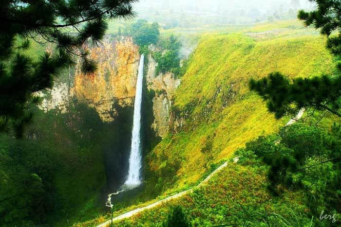
Waterfall Balangdaras Spoiler for Balangdaras

Balangdaras waterfall is a waterfall located 25 km from City Pelaihari, Tanah Laut, South Kalimantan, precisely in DesaTanjung, Pelaihari, Tanah Laut. Balangdaras waterfall has a beautiful panoramic mountain and exotic. Being at altitude mountains with an altitude В ± 45 meters.
Waterfall Srambang Spoiler for Srambang

Srambang is one tourist attraction in the form of Ngawi District waterfall. Located at the foot of Mount Lawu, District Jogorogo, about 5 km to the south of Jogorogo market. Height of this waterfall is almost reached 25 m. It is a tourist attraction that is often visited by tourists both local and outside the region. Atmosphere the cool and cold mountains make this place always crowded with visitors visitors. The area has been paved road to the location making it easier for travel. Location waterfall adjacent to the boarding school srambang Condro Mowo. If you bring your motorcycle can go straight to the location without having to walk away and you do not have to worry about security issues because it has provided a parking area, although not so broad. But if you bring a car, you have to walk about 500 m to get to the location of water terjun.Anda can enjoy the cool atmosphere and feel the fresh mountain waterfall when not wet with water. Visitors can bathe and enjoy the food and beverages as well as roasted corn on lokasiair plunge. Many traders who peddle food and warm drinks. The deadline for requests is up to 3 pm. This is to anticipate the occurrence of landslides in the waterfall area, especially in the rainy season, many Pacet and prone to landslides.
Curug Cipendok Spoiler for Cipendok

Cipendok waterfall is located in the middle of the village of Karang, District Cilongok, Curug Cipendok Banyumas.Airterjun District has 92 meters. Eve in the cool surroundings and along roads leading to it there are areas around the region have perkebunan.Di campground and a lake called Telaga Pucung. Location terjunini water is fairly easy to achieve. Already paved the road to the location of all. Until the location of parking, and walked to the location of the waterfall, we really can enjoy the natural scenery around while berolahraga.Di path to the location, many stalls selling Mendoan, pure milk which can be found at stalls home residents. Plantation tomatoes, peppers and celery is quite interesting dinimati on the way to the location. Not to mention the small rivers with clear water flowing, can invite us to come down for a moment it felt cool and crisp mountain water. When the big day like a holiday feast, this location is pretty crowded every year.
Curug Luhur Spoiler for Luhur

Luhur waterfall is a waterfall that was in the area Ciomas subdistrict, Bogor. Height 624 m. Waterfall that has two parallel waterfall is located on Mount Salak about 70 km south of Jakarta. Flow of water in this waterfall strong and quite dangerous. Similarly, there were whirlpools beneath a strong and can drag people into it. This waterfall is one tourist attraction in this area. This area is also famous for producing sweet, dried pineapple and durian Rancamaya.
Curug Belt Spoiler for Belt

Belt waterfall is a waterfall located on the slopes of Mount Ciremai, Cilengkrang Valley, Jalaksana, Kuningan regency, provincial West Java, Indonesia. Height of this waterfall is about 20m, with adequate water flow deras.Di the flow of water from the waterfall belt, there are several hot springs. To reach the waterfall belt from the direction of Cirebon, Arriving at the market jalaksana (krucuk market), there is a T-junction turn right, slightly uphill road because it leads to the slopes Ciremai. To reach the waterfall, have to walk about 1 hour through the path, and through the mountain forests Ciremai relatively unspoiled. Not far from the waterfall Belt, approximately 300 m, there is a waterfall Sawer, with a height of 60 m. waterfall
Curug Sewu Spoiler for Curug Sewu

Sewu waterfall is located in Patean, Kendal and is a three-level waterfall with a height of about 80m. The name of the waterfall is taken from the name of the village where the waterfalls are located, namely his right Curugsewu village in District Patean, the distance is 40 kilometers from the town of Kendal by first past the city and Sukorejo Weleri. Waterfalls Curugsewu have the privilege and unique compared to other waterfall, with a total height of 70 meters consisting of 3 plunge, each having a height of 45 meters, 15 meters and 20 meters. looks very beautiful and charming to look at, especially at certain times, from the waterfall appears rainbow blend of dazzling diversity of colors. To provide convenience to visitors, about the location of Waterfall Curugsewu been equipped with recreational parks and complementary facilities such as stage children's playground, mini zoo and swimming pool and various other facilities. Still on the privileges and keunikkannya, was AirTerjun Curugsewu is the highest waterfall in Central Java. To complete range of amenities and facilities that already exist, Mini Train, Jet Coaster and Swimming Pool with national standards have been built. In order to provide excellent service and satisfying.
Giri beads Spoiler for Girimanik

Giri bead is a natural tourist area cool valve with a very beautiful natural panorama. This tourist region there are three waterfalls, called Manik Moyo Waterfall, Tinjo Moyo, and Condromoyo. Beads Waterfall Moyo has a height of 70 meters Waterfall Tinjo while Moyo has a height of 30 meters. Not far from Manik Moyo Waterfall there is a place of sacred relics or ruins Raden Mas Saidyang known as the Stone Resi.